
<< >>
CHIN中国的 - D - THAI ไทย
Water and groundwater 03: salinization of groundwater, oversalted wells
Destruction of natural coastal vegetation - groundwater wells near the coastline sucking saltwater - rising sea level brings more saltwater
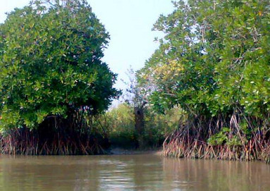
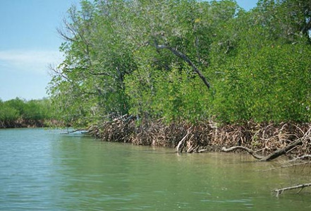
Mangrove forest in Pichavaram in southern India [3]
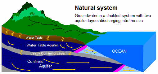
Scheme with saltwater and groundwater 2 with a doubled groundwater system, and both are draining into the ocean [10]
Scheme with saltwater and groundwater 02, groundwater well is oversalted and a groundwater bubble has been formed between the well and the coast line [13]
by Michael Palomino (2013)
Part 1: groundwater in general - part 2: pollution and contamination - part 3: salinization, oversalted wells
| Teilen / share: |
Facebook |
|
Twitter
|
Salinization of waters near the coast line (coastal waters)
Water contamination: salinization of water
Salinization of groundwater near the coats line
With normal conditions groundwater is draining into the sea
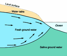
Normal conditions at coast lines are these: drinking groundwater and saltwater are in a balance, and drinking groundwater is draining into the sea because it is staying under pressure from other groundwater in the mountains. Additionally saltwater is more dense than drinking groundwater from the continent and is always placing itself UNDER the continental drinking groundwater.
Scheme with saltwater and groundwater 1, groundwater is draining into the sea, and below is saltwater groundwater [9]
Fresh groundwater is always under pressure (because there is always coming more groundwater from the mountains) thus fresh groundwater is always draining into the sea. Below the sea is forming an own salty water table (sea groundwater) which cannot rise much because saltwater has got a higher density than fresh water and is automatically laying itself under the fresh water [web06].
Between fresh water and saltwater is a mixed zone. Water table on the continent is always over sea level and makes enough pressure pushing away the saltwater of the ocean.
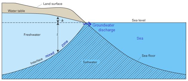
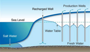
Scheme with saltwater and groundwater 2 with a doubled groundwater system, and both are draining into the ocean [10]
In this case there is an upper and a lower groundwater system being separated by an impermeable layer. Both groundwater systems are draining into the sea. The upper water table is over sea level and can push away salt water intrusion. The lower water table is reaching sea level after some kilometers. This lower groundwater system seems to have it's origin in central mountains of the continent.
Scheme with saltwater and fresh groundwater 03 with V-formation [11]
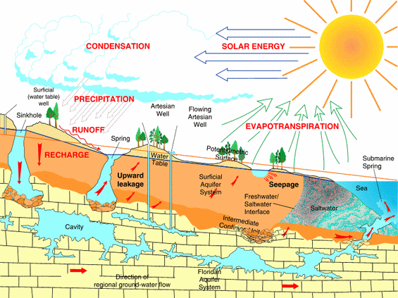
Scheme with saltwater and fresh groundwater 04 with additional cave systems below [12]
Sometimes groundwater is also passing complete cave systems draining into the sea like in this scheme when there is a limestone or a sandstone layer in which the groundwater can work out caves.
The scheme here shows the coast line principles in Florida with it's caves and underground fresh water springs in the sea.
And now comes industrialization:
Oversalted groundwater by overexploitation of groundwater near the coastline
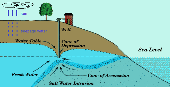
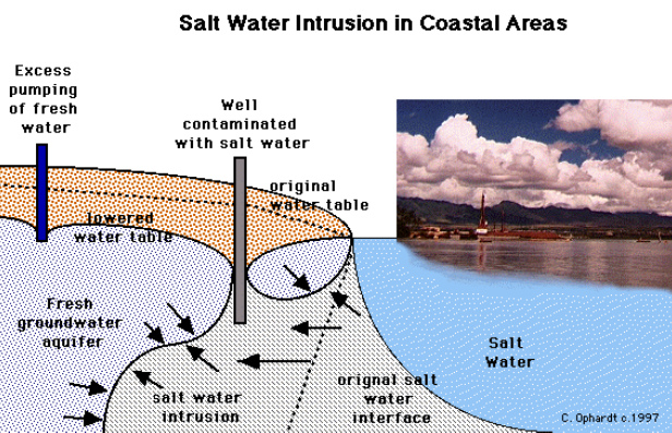
When groundwater near the coastline is overexploited by groundwater wells - by coastal towns, by industries or by irrigation systems of agriculture in the coastal region - then the water table is collapsing at the location of the well. The groundwater stream is stopped and soaking is even turned around. The water table can even sink under sea level with this. In this way saltwater is facilitated to penetrate respectively the denser saltwater from the sea groundwater is really "invited" and is torn to the well which is placed near the coast line.
Scheme with saltwater and groundwater 05, groundwater well is oversalted, and a fresh groundwater blister has been formed between the well and the coastline [13]
Scheme with saltwater and groundwater 06 with a well near the coastline, sea saltwater will reach the tube of the well soon [14]
When the extraction of fresh groundwater near the coastline is going on, then the saltwater is reaching the well. The well is oversalted and is unusable. Between the well and the coastline a fresh water blister is formed, and the water table is falling UNDER sea level and the fresh groundwater is loosing with this any pressure against the saltwater (sea groundwater).
Scheme with saltwater and groundwater 07: the groundwater well is oversalted, and between the well and the coastline a water blister has been formed [15]
Agriculture in coastal regions with groundwater wells - and oversalted wells
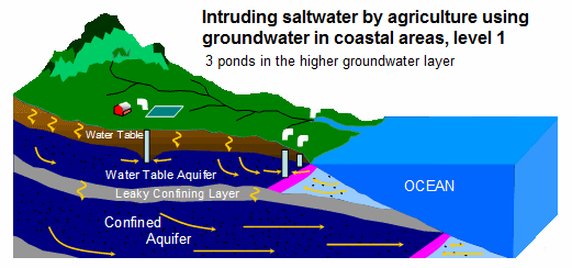
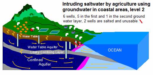
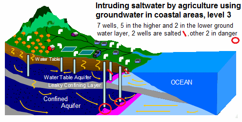
The next three schemes show step by step the salinization of several groundwater wells by agriculture with irrigation systems near the coast line. It's no use when always more wells are drilled because salty sea groundwater is automatically attracted by the wells.
Scheme with saltwater and groundwater 8, 3 groundwater wells for agriculture [16]
Both wells at the coastline are near the mixed zone. Both wells are sucking the mixed zone (pink).
Scheme with saltwater and groundwater 9, there are 4 groundwater wells now for agriculture [17]
Both groundwater wells which were first at the coast line are oversalted with their ends in the mixed zone (pink). The water table of the last part of the groundwater system has dramatically lowered.
At the same time a new deep groundwater well into the lower groundwater system was drilled, and much water was pulled out thus the mixed zone of the lower groundwater system (pink) has pulled back, and the mixed zone of the lower system will be on the level of the first mixed zone soon.
Scheme with saltwater and fresh water 10, now there are 7 groundwater wells for agriculture [18]
Higher mixed zone (pink) has also reached the third well and also the third well is oversalted now. The water table of the upper groundwater zone is under sea level in big parts now. The first well is fully standing in salty sea groundwater. The second well which was oversalted was drilled deeper reaching the lower groundwater system, but both deep wells are also in danger of being oversalted now because the salty mixed zone (pink) is sucked in a strong way (red circles).
Intruding saltwater can be given a block by an injection well. This is happening for example in California and also in Shanghai.
Scheme with saltwater and groundwater 11 with 4 wells and an injection well [19]
This injection well between the wells and the beach can reach that the water table is over sea level again pushing away the saltwater (sea groundwater).
But such an injection well needs much energy and needs much fresh water and thus is very expensive. Mostly old oversalted wells near the coastline are used as injection wells. Other measures would be
-- water saving measures in agriculture with perforated tubes
-- construction of reservoirs in the mountains or installation of lakes as water reserves for coastal towns or coastal agriculture.
For example between 1900 and the 1950s California had huge problems with oversalted groundwater wells:
<Seawater intrusion happens when there is too much overdraft near the ocean and saltwater seeps into the aquifer. When saltwater gets into the aquifer, that part of the aquifer is contaminated and can never be used again. Some coastal wells have been shut down because of seawater intrusion.> [web07]
Here is the history about oversalted groundwater in the region of Los Angeles from 1900 to the 1950s:
<In coastal areas where groundwater is used for potable or agricultural purposes such as the Central and West Coast Basins (CWCB), intrusion can be a serious problem resulting in the shut down of wells or necessitating expensive desalination treatment. In the early half of the 20th century, groundwater extractions in the CWCB were double natural replenishment, causing severe overdraft and lowering of the groundwater elevations to over 100 feet below sea level. This greatly increased the extent of the seawater intrusion inland (Figure 1b). Callison and Roth (1967) reported that seawater intrusion was first noted in Redondo Beach in 1912, Hermosa Beach in 1915, and El Segundo in 1921. The California Department of Water Resources (CDWR, 1962) estimated that up to 600,000 acre-feet (af) of seawater intruded into and contaminated the Los Angeles coastal aquifers by the late 1950s.
To address this problem, in 1951 the Los Angeles County Flood Control District (LACFCD) used an abandoned water well in Manhattan Beach to inject potable water to test whether pressure could be built up in a confined aquifer to block the intrusion (Lipshie and Larson, 1995). The test worked, so LACFCD performed subsequent tests with additional wells to successfully create a pressure ridge or "wall" along the line of injection wells to overcome the pressure of the intruding seawater (Figure 1c). The results are well documented in a report by CDWR (1957).> [web19]
Many coastal federal states of "U.S.A." have big problems with oversalted groundwater near the coast line until today [web06].
Oversalted groundwater by rising sea level
Rising sea level has it's effects
-- penetrating saltwater
-- higher water table on the continent which is always in connection with sea level, and in flat regions even swamps can be formed.
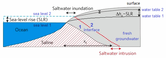
Scheme with risen sea level 01 [20]
The effects of a higher sea level are
point 1: penetrating saltwater on the ground (sea groundwater) against the continental fresh groundwater
point 2: a rise of the continental water table in general
Tis means: flat coastal areas with big plains between only 0 and 1 m over sea level are in danger of forming swamps, and then the swamp is oversalted at the end.
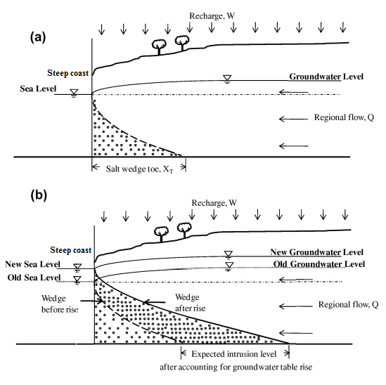
Scheme with a risen sea level 02 [21]
The higher sea level has the effects
point 1: penetrating saltwater on the ground (sea groundwater) against fresh groundwater
point 2: a rise of the continental water table in general
In this case the coast line is a cliff and the continental water table is relatively deep under the surface thus a higher sea level does not provoke any swamp yet.
So there is a conclusion:
Cliffs will be important for surviving a higher sea level.
And landscapes with flat sandy beaches will be destroyed and oversalted.
And flat towns with sandy beaches are nowadays in danger of life: Shanghai, Rio, Sydney, sinking Bangkok etc.
What will happen with these towns?
-- in the case of sinking towns they must be partly rebuilt in safe areas with water systems from the rainy mountains without using groundwater (in the case of sinking metropolis)
-- in the case of safe and hard grounds the towns can rise their territory by 5 meters rebuilding the town on the same location
-- or dike systems can be built on hard and safe ground blocking any view but there is always the danger that the sea will fill up the basin one day.
Rising sea level and oversalted groundwater: example Micronesia
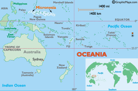
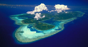
Flat islands and plains have hardly any chance against rising sea level. This shows us Micronesia, a group of islands with an extension of about 2,000 km, where some islands are already being oversalted.
Map with Philippines, Australia and Micronesia [22]
Flat islands in Micronesia, for example Yap Islands [23]
On islands which are in danger of being oversalted by rising sea level groundwater is oversalted. On different groups of islands of Micronesia in the Southern Sea [east of Philippines] groundwater is already oversalted and inedible as an article says clearly with the title "Rising sea level oversalting groundwater" (orig. German: "Steigende Meeresspiegel versalzen das Grundwasser")
(http://www.dw.de/steigende-meeresspiegel-versalzen-das-grundwasser/a-5463581)
<Groups of islands like Micronesia are in danger of drowning into the rising oceans. The precursors of the threat can be felt now already. Groundwater is oversalted and drinking water is scarce. [...] Rising sea provokes that saltwater is mixing into fresh groundwater. Fresh water deposits are made inedible and agricultural irrigation is always more complicated. Soil is also oversalted and cannot be used for years.>
(orig. German:
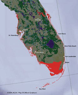
<Inselgruppen wie Mikronesien drohen in den steigenden Weltmeeren zu versinken. Die Vorboten der Bedrohung sind schon heute spürbar: Das Grundwasser versalzt und das Trinkwasser wird knapp. [...] Durch die steigenden Meere mischt sich Salzwasser ins Grundwasser. Die Trinkwasser-Vorräte werden so ungenießbar und die landwirtschaftliche Bewässerung immer schwieriger. Die Böden versalzen und sind damit oft auf Jahre unbrauchbar.>)Next victims of rising sea level are Florida, Vietnam with the Mekong delta, and many other deltas in the world are affected. See the maps below:
Florida loosing territories with a rise of sea level by 1 m [24]
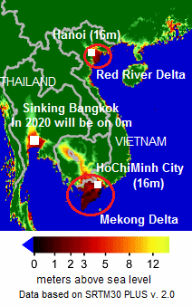
Vietnam loosing territories with a rise of sea level by 1 m, map [25]
Vietnam will loose territories in Mekong Delta and Red River Delta. Bangkok is sinking 5-8 cm per year, about 5 mm per month. But the Thai government is concealing this and no measures are taken until today (2013).
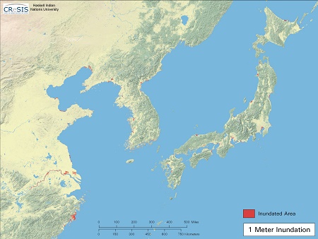
Losses of territories in Asia after a rise of sea level by 1m
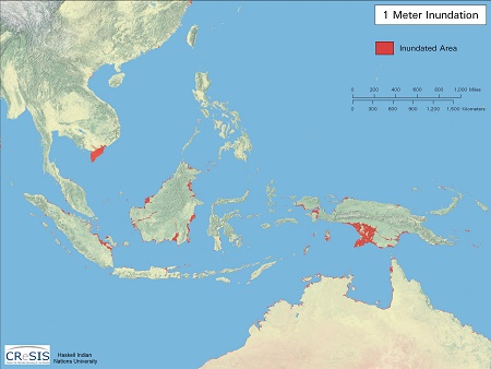
Vietnam, Malaysia, Indonesia and Papua New Guinea will loose territories after a rise of sea level by 1 m, map [26]
In Vietnam Mekong delta will go. And more deltas will go on Borneo and on Papua New Guinea.
China and Japan with losses of territories after a rise of sea level by 1 m, map [26]
The lower part of Tokyo and some more lower parts of more Japanese towns will go [26].
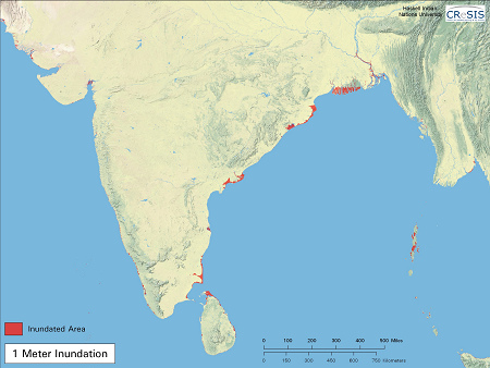
India, Ceylon, Bangladesh and Maledives Islands will lose territories after a rise of sea level by 1 m, map [26]
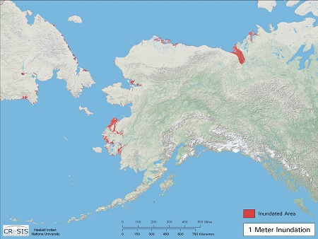
Losses of territories in "America" after a rise of sea level of 1m
Alaska will lose some territories after a rise of sea level by 1 m, map [26]
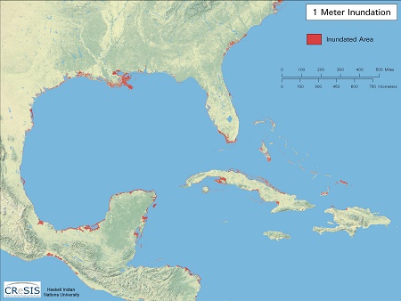
South eastern "U.S.A." and Caribbean will loose territories after a rise of sea level by 1 m, map [26]
Parts of Florida, of Lousiana (Mississippi delta) and parts of Cuba and Belize will go.
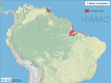
Peru, Ecuador, Columbia and Brasil will loose territories after a rise of sea level by 1 m, map [26]
There are some plains no northern Peru and the delta of Guayas River near Guayaquil in Ecuador which will go. Also parts of the big delta of Orinoco River and of Amazonas River will go.
Losses of territories in Europe and northern Africa after a rise of sea level of 1m
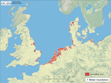
Germany, Holland, England, Denmark, Norway and Sweden will loose territories after a rise of sea level by 1 m, map [26]
Parts of the coast line in England, Wales, Holland, Germany and Denmark will drown. Holland has big dike systems, but if they can withstand a rise of sea level of 1 m may be put into question. Amsterdam and The Hague are in danger etc.
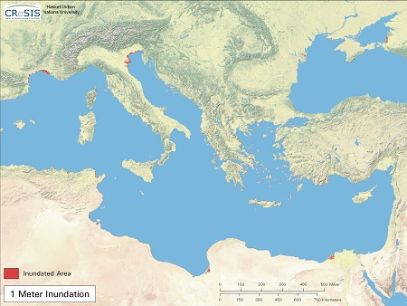
Medium and eastern Mediterranean, losses of territories after a rise of sea level by 1 m, map [26]
Camargue in France (in Rhone delta) and parts of Po plain in Italy will go. Also Alexandria in Egypt and parts of the region of Ajdabija in Libya will go.
Part 1: groundwater in general - part 2: pollution and contamination - part 3: salinization, oversalted wells
| Teilen / share: |
Facebook |
|
Twitter
|
Sources
[web01] Shrimps consumption destroys mangrove forests (Shrimps-Konsum zerstört Mangrovenwälder):
http://www.greenpeace.de/themen/meere/nachrichten/artikel/shrimps_konsum_zerstoert_mangrovenwaelder/
[web02] Mangrove: http://en.wikipedia.org/wiki/Mangrove
[web03] Mangroven:
https://gc21.giz.de/ibt/gc21/area=portal/style=myso/paint=myso/de/usr/modules/gc21/ws-chatderwelten/info/ibt/portal/themen/klimawelten/113020.sxhtml
[web04] Mangroves are disappearing faster than other forests: http://www.planethopia.info/earth/mangroves-are-disappearing-faster-then-other-forests/
[web05] Saltwater intrusion: http://en.wikipedia.org/wiki/Saltwater_intrusion
[web06] Saltwater intrusion (orig. German: Salzwasserintrusion): http://de.wikipedia.org/wiki/Salzwasserintrusion
[web07] Our groundwater, California: http://www.watersavingtips.org/groundwater.html
[web08] Battling seawater intrusion in the Central & West Coast Basins: http://www.wrd.org/engineering/seawater-intrusion-los-angeles.php
Photo sources
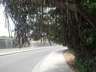
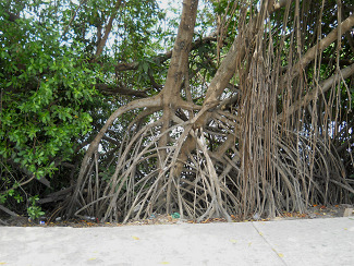
[1+2] Mangroves at an inner coastline in Cartagena, Columbia: photos by Michael Palomino 2012
[3] mangroves in Pichavaram, India: http://creative.sulekha.com/the-mangroves-of-pichavaram_379478_blog
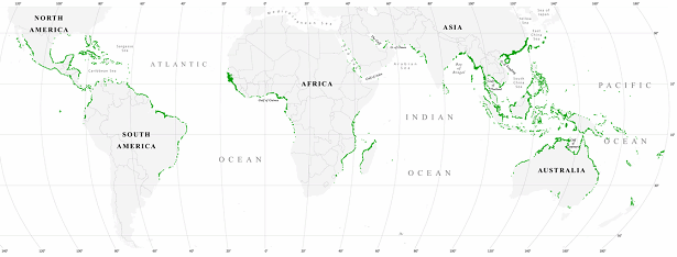
[4] world map of mangrove forests 2000: http://en.wikipedia.org/wiki/Mangrove
[5] mangroves on Dampier archipelago, Australia: http://wamuseum.com.au/dampier/explore_mangroves.asp
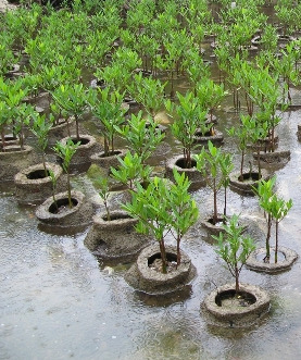
[6] reforestation of mangroves: http://www.planethopia.info/earth/mangroves-are-disappearing-faster-then-other-forests/
[7] scheme of impoverishment of coast lines and intruding saltwater: http://en.wikipedia.org/wiki/Saltwater_intrusion
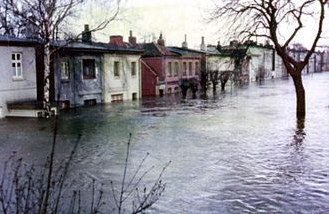
[8] storm tide in Hamburg Wilhelmsburg District in 1962: http://de.wikipedia.org/wiki/Sturmflut_1962
[9] scheme with saltwater and groundwater 1: http://pubs.usgs.gov/circ/circ1186/html/wq_factors.html
[10] scheme with saltwater and groundwater 2 with doubled groundwater systems both draining into the ocean:
http://www.ecy.wa.gov/climatechange/risingsealevel_more.htm
[11] scheme with saltwater and groundwater 3 in V-formation: http://de.wikipedia.org/wiki/Salzwasserintrusion
[12] scheme with saltwater and groundwater 4: http://watersome.blogspot.com/2012/09/groundwater-formation.html
[13] scheme with saltwater and groundwater 5 with groundwater wells and salinization:
http://earthsci.org/education/teacher/basicgeol/groundwa/groundwa.html
[14] scheme with saltwater and groundwater 6, wells provoking danger of salinization:
http://earthsci.org/education/teacher/basicgeol/groundwa/groundwa.html
[15] scheme with saltwater and groundwater 7, oversalted wells and bubble of fresh groundwater: http://www.elmhurst.edu/~chm/vchembook/301groundwater.html
[16, 17, 18] scheme with saltwater and groundwater 8, 9, and 10, agricultural wells are oversalted: http://www.ecy.wa.gov/climatechange/risingsealevel_more.htm
[19] scheme with saltwater and groundwater 11 with 4 wells and 1 injection well: http://intrusion.usegrid.net/
[20] scheme of intruding saltwater by higher sea level 01: http://www.nature.com/nclimate/journal/v2/n5/full/nclimate1413.html
[21] scheme of intruding saltwater by rising sea level 02: http://www.sciencedirect.com/science/article/pii/S0309170811001187
[22] map with Australia, Philippines and Micronesia aside: http://www.worldatlas.com/webimage/countrys/oceania/fm.htm
[23] Yap Islands in Micronesia: http://www.doaaraku.com/exotic-islands/tourist-information-yap-islands-micronesia/
[24] Florida with risen sea level by 1 m loosing territories: http://www.nasa.gov/vision/earth/environment/sealevel_multimedia_prt.htm
^

